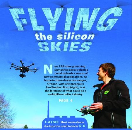
Drones are no longer aviation’s next big thing. They are a big thing right now. They are currently soaring over Oregon and Washington thanks to three Oregon test ranges recently approved by the FAA, simplified FAA drone rules, and integrated software for flight planning, drone management and data analysis. Here’s an executive summary (pdf).

Verizon bought Skyward in 2017 for cellular integration into drone ecosystems. Skyward already has partnerships with a number of cloud based drone data analytic companies including PrecisionHawk, DroneDeploy, and senseFly.

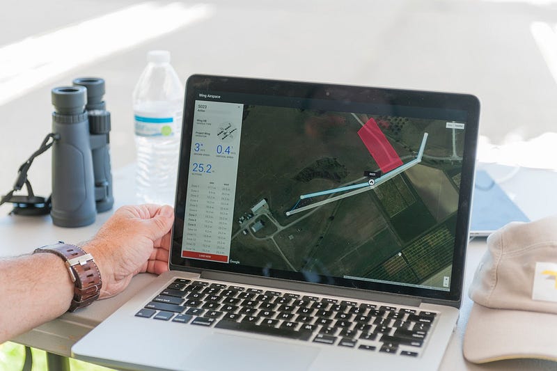
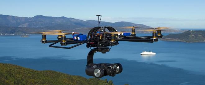
The FAA granted Skyward a temporary waiver to enable pilots to fly the Percepto Sparrow drone from their homes during near a wildfire in Washington in 2020.

The FAA enabled Skyward to conduct entirely remote flights, with no onsite crew, at the Big Hollow wildfire in the Gifford Pinchot National Forest.

The FAA now has a new permanent BVLOS integration initiative, called BEYOND to advance Beyond Line of Sight operations in drone testbeds such as Oregons.

Beyond the visual line of sight (BVLOS) flying enables Skyward software to use the Verizon 4G/5G network using Percepto’s autonomous Sparrow drone. The software provides visual data management and analysis while their Airborne LTE Operations (ALO) suite keeps the connection hot.

The FAA’s Low Altitude Authorization & Notification Capability (LAANC), allows Part 107 pilots to gain fast access to U.S. controlled airspace via Skyward in just seconds. It integrates LAANC access and flight planning tools for complete ops management, including equipment maintenance, pilot credentials, and a system of record. Verizon has already bought a bunch of 3.5GHZ (CBRS) licenses in the upper Columbia River Gorge, so watch this space.
Drones are now becoming Sky Taxis…and they’re taking off. The market for eVTOL aircraft, air taxis and personal air vehicles — could be $1.5 trillion by 2040, according to analysis from Morgan Stanley, with passenger travel expected to account for $851 billion.

Major eVTOL players, include the Uber Elevate, Joby Aviation, the Airbus’ Vahana team (in Umatilla), and the Boeing/Google Wisk. Geoff Bower, chief engineer for the Vahana program, holds the same title at a new startup, Archer.

If Uber gets an average load factor of 2.7 to 3 passengers in its four-seat (plus one pilot) taxis, by 2023, the company says it can get the price per passenger mile down to $1.84, which is comparable to Uber’s ground service.
Autonomous flying vehicles that carry people are being tested in Oregon by Airbus. Direct-drive electric motors and automation eliminates the need for expensive engines, gearboxes, transmissions and pilots while metal 3D printing can bring dreams to reality 100 times faster.

Other “sky taxis” are being developed by a Daimler-backed German venture Volocopter, Germany’s Lilium, Swiss-based Passenger Drone, China’s EHang, China’s Zhejiang Geely, which owns Volvo, bought Terrafugia, Slovakia’s AeroMobil, Japan’s Cartivator Project, Kitty Hawk, backed by Google co-founder Larry Page, Zunum and others. Zunum, a Kirkland-based startup with backing from Boeing and JetBlue, plans to deliver its first hybrid electric plane in 2022.

The Zunum ZA10 electric aircraft will bring breakthrough performance to regional aviation, paving the way to affordable air services costing about $0.08 per passenger mile. Two Northwest companies — MagniX, an electric propulsion venture headquartered in Redmond, Wash.; and Harbour Air Seaplanes, an airline based in Vancouver, B.C. — have firm plans to create the first all-electric fleet of commercial airplanes. Harbour Air will convert all its seaplanes to electric for first all-electric airline.

Today’s batteries provide between 180 and 240 watt-hours per kilogram, according to battery data from Wood Mackenzie. But battery maker 24M, a DOE-funded startup, says it can already deliver 350 watt-hours per kilogram. They believe that it can be refined to 450 or 500 watt-hours per kilogram. Boosting range from 30 minutes to 60 minutes could be huge. With 1,000 watt-hours per kilogram an electric aircraft would be equivalent in range to today’s aircraft. It could happen in 5-10 years. It would be a paradigm shift for regional airlines.
- Airbus first flew their automated Sky Taxi in 2017, at the Pendledon airport. This is NOT fantasy.
- Uber Elevate envisions a demonstration fleet of flying taxis to take off in Dubai and Dallas-Fort Worth in 2020. Elevate uses Aurora Flight Sciences electric VTOL which was bought by Boeing. Boeing, of course, already owns Insitu, the Oregon drone trailblazer.
Boeing’s Near Earth Autonomy provides the navigation software and SparkCognition has the AI. Horizon X is here. - Daimler-backed Electric VTOL ventures include Volocopter and Lilium. They might be a good match for Oregon.
Daimler has their North American headquarters on Swan Island and owns Moovel the leading on-demand/transit ride app. Daimler’s self-driving truck was also developed here. Skyward.io, the FAA approved drone flight plan software, is also based in Portland. - Sprint, AeroVironment and SoftBank are conducting tests using a High Altitude Platform Station (HAPS) over the island of Lanai, Hawaii using 2.5 GHz links to provide wide area broadband. The higher you go, the more people you can reach. That is the basic concept behind HAPSMobile – cell tower positioned “permanently” 13 miles high. The ultralight Hawk30 airplanes would fly above the clouds at an altitude of 13 miles (20 kilometers) for months at a time. Each aircraft would have a wingspan of roughly 260 feet (78 meters) and sport 10 electric-powered propellers. Average flight speed would be about 70 mph.
HAPSMobile is targeting 2023 for mass production of the Hawk30 planes and the launch of commercial service. - Boeing which owns both InSitu and Aurora Flight Sciences, says its solar-powered, high-altitude, long-endurance Odysseus drone with its first flight in the spring of 2019, will offer similar capabilities.
Could these high flyers save the Coast Guard, the Air National Guard, Sheriff’s patrols, and the Forest Service hundreds of millions of dollars every year? That’s the plan. Lower altitude wide area surveillance drones could relay “persistant vision” as well as provide mobile phone service throughout the Coast Range and the Columbia River Corridor.
Airbus Aerial merges satellite and drone imagery, with software and analytics for a variety of customers. “Drone As A Service” is software driven.
This paper promotes designating the Columbia River – from Astoria to Umatilla – as an official skyway…because it saves money, time and lives.

The Pendleton UAS Range is well on its way to be self-sustaining. Expanding UAS facilities in Astoria, Kelso, Scappose, Troutdale and Hood River might be the next step – before states like NY, Nevada and North Dakota grab the lead.
Drones can have continuous GPS beaconing and automatic detection of obstacles for improved safety, speed and efficiency. The Electric VTOL Newsletter has the latest news.

The Aerocar, designed and built by Moulton Taylor in Longview, Washington in 1949, was the Northwest pioneer.

Could Oregon aerospace companies like Epic Aircraft, Statos Aircraft, Sherpa, X-Air and others get into the drone business? Oregon has cellulose nanofibres that are stronger than carbon fiber, the software and hardware expertise, and the only FAA cleared test ranges on the West Coast. Here’s where most of America’s drones are made.
In February, 2017, Verizon acquired Skyward which is likely to drive widespread adoption for in-flight wireless connectivity through their Airborne LTE Operations (ALO) initiative. Ericsson and China Mobile have a 5G drone that can handoff between towers suggesting a 15km (10 mi) range on a DJi Inspire and Gbit/s speed at 3.5GHz. Drones over the 55-pound weight limit trigger a requirement for a special federal license.

Today, Insitu has 1,300 employees, including 900 in the Gorge, with Gorge aerospace industry employing about 1,700 people across 17 companies in Hood River, Wasco and Sherman, and Skamania and Klickitat counties, according to the Gorge Technology Alliance. The Coast Guard hopes to deploy drones for its entire national security cutter fleet.


Here’s my article in Drone Life: Can Rivers be the First Drone Highways? and Uber’s on-demand drone plan: Uber Elevate.

Get a Drone Pilot’s License
First Responders, utility companies and citizens (especially those involved in Neighborhood Emergency Teams) might benefit from a drone license. Airmap shows you where you can fly.

The DJI GO app that controls DJI’s Phantom and Inspire uses Geospatial Environment Online (GEO) software to avoid flying drones near airports and other sensitive locations.
The control software typically tells the pilot to land when you fly within 5 miles of an airport and more than about 100 ft high. Low Altitude Authorization and Notification Capability, or LAANC, will allow drone operators to apply for instant, digital approval to fly in U.S. controlled airspace.
FAA Rules Ease
The FAA issued Small UAS Rules (Part 107 pdf) for routine non-recreational use of drones in June, 2016. The new FAA rules make it easier to operate a UAS businesses. A pilot license is no longer required.

Tornado damage has been assessed under FAA’s Part 107 regulations. Under Part 107, commercial operators are limited to flying with visual line of sight only, and other than a knowledge test, there is no training requirements for pilots.

500Below is the first peer to peer network for drone pilots. The app enables drone owners to make money with their drone skills.
Intel’s MAVinci drones do city mapping faster and cheaper. Industries like mining, real estate, agriculture and infrastructure inspection such as utilities, wind farms and oil and gas may benefit most. If you have a structure that’s 700 feet tall, you can operate up to 400 feet above the top of it, so 1,100 feet total above ground, as long as you stay within 400 feet of the building.
Skyward’s flight operations system got a major upgrade with The FAA’s Part 107 drone rules which is being integrated with flight planing software like the the DJI-PH Farming package and PrecisionHawk DataMapper to provide a holistic drone workflow. Other flight planning apps on the market include DJI’s GS Pro and Map Pilot from Drones Made Easy.
Skyward software is FAA compliant and keeps track of a user’s fleet, while PrecisionHawk DataMapper provides cloud-based data analysis. Their integration streamlines the business of drone operations.
Google’s Project Wing has its own UAV air traffic control platform that might keep a massive volume of airborne drones from crashing into buildings, people or each other. Project Wing’s UTM (UAS Air Traffic Management) leans heavily on other Google products like Maps, Earth and Street View to navigate drones around obstacles and plan routes.
Next Up: Beyond Line of Sight
Over the next two and a half years, ten state, local and tribal governments will collect drone data involving night operations, flights over people and beyond the pilot’s line of sight, package delivery, detect-and-avoid technologies and the reliability and security of data links between pilot and aircraft.
Long range drones can fly 50 miles or so. Verizon will soon offer data plans for drones, allowing pilots to stream video and transmit data. Loose cellular or GPS? No problem. Sky Taxis use Lidar dot clouds – just like autonomous cars.
The Low-Altitude Tracking and Avoidance System connects airspace management technologies, such as sense and avoid, geo-fencing, and aircraft tracking, into a service package for commercial and recreational drone operators as well as regulators and air traffic controllers.
PrecisionHawk believes Extended Visual Line Of Sight (EVLOS) rules will extend range up to 12 times over line of sight. For example, BNSF Railway will explore using UAS to inspect rail infrastructure, according to the FAA. Pioneer in BVLOS technology, Delair-Tech drones travel 30 miles.

Fuel Cell drones can have a 9 hr flight time.

PrecisionHawk has been approved by the FAA for beyond line of sight (BLOS). PrecisionHawk uses an airspace display technology called LATAS to help track the aircraft and avoid potential hazards such as trees, powerlines or manned aircraft. The LATAS web application provides an extra layer of safety and protection for any operator flying under Part 107. PrecisionHawk’s investors include Intel Capital.
Qualcomm says cellular connectivity can enables drones to operate beyond visual line of sight (BVLOS).
Qualcomm and AT&T will test drones on commercial 4G LTE networks. The UAS trials will be based on Qualcomm’s Snapdragon Flight platform. Verizon has invested in Skyward, the Portland-based management solution and PrecisionHawk, the provider of aerial data and safety platforms for drones. Verizon’s LTE network, Harris’ ADS-B network, DigitalGlobe’s Geospatial Big Data Platform and PrecisionHawk’s LATAS (Low Altitude Traffic and Airspace Safety) platform, serve as a pathway for Beyond Visual Line of Sight (BVLOS) regulations.

A new certification process sets forth requirements for access to Verizon’s 4G LTE network for unmanned aerial systems (UAS). No doubt Airbus drones will use Airbus/OneWeb LEO satellites for constant connectivity. SpaceX plans an even larger LEO broadband network.
It’s The Law
The UAS Integration Pilot Program is a directive signed by President Trump, that allows the FAA and the Transportation Department to grant waivers to allow flights over people, at night and beyond the line of sight of the drone operator. Trump directed the Transportation Department to create a test program and invite proposals submitted by partnerships between drone operators and local, state or tribal governments.
Overwatch Imaging, out of Hood River, specializes in precision aerial photography from small- and medium-sized unmanned aircraft.

In early 2017, Logos tested it’s Redkite Wide-Area Motion Imagery (WAMI) sensor aboard an Insitu Integrator at Boardman. The Logos Redkite sensor fits inside the payload bay of a Group 3 unmanned aircraft system (UAS) like the Insitu Integrator for city-wide surveillance, 24/7. Portland’s OGSystems generates user defined, on demand 3D derivative products such as Digital Terrain Models, Digital Surface Models and true color encoded point clouds from wide area surveillance.
Wide Area Surveillance packages are being tested on Insitu’s Integrator aircraft in Eastern Oregon for 24/7 “Eye in the Sky” surveillance that may revolutionize policing – for better AND for worse. The Redkite package consists of a 50-megapixel sensor that snaps an image every other second. It can monitor a nearly 5 by 5 square mile area from 12,000 feet. Redkite stores the collected imagery on solid state drives and also beams it to ground stations via data link. How much is Logos Tech worth to Boeing? How much to Airbus? China? Somebody else. A billion dollars in bitcoin?
Oregon’s drone ranges, such as the Pendleton UAS Range are the only places on the West coast that you can legally fly a large drone (over 55 lbs). Two words: Electric Jet.

Prepare for Takeoff
Oregon’s nascent drone business is now flying high. The 3 Drone Ranges, FAA part 107 drone rules, the dozens of Oregon drone manufactures and software developers, and companies like Skyward IO whose flight operations system are being integrated with industrial-strength cloud-based software like Drone Deploy are making flight planning and data analysis fast and easy.

On a budget? The $250 YI 4K camera on a $330 Phantom 2 can do the job. PTGui can stitch hundreds or thousands of images together. Bang…Zoom.
Google’s Project Wing and Chipotle are testing delivery of burritos on the campus of Virginia Tech. The burrito-bearing aircraft will be flown by automation, but human pilots will be standing by to take control if necessary. Drone technology is leaving older, slower, expensive and un-responsive solutions in the dust.

ABI predicts that commercial drone revenue will grow at 51% annually from 2014 through 2019. By 2019, the commercial drone market will be worth roughly five times as much as the hobbyist market and more than twice as much as military and civil service drones. The White House believes commercial drones could generate more than $82 billion in the next decade.

Oregon’s Drone Ranges
Commercial certification of UAVs by the FAA for operation over land and water in the United States is anxiously anticipated by the fledgling industry. Operators in Oregon hope to provide commercial services for the motion picture industry, real-estate, search and rescue, agriculture, and many other industries.
On June 10th, 2014, the FAA approved the first commercial UAV use over land of the AeroVironment Puma. Last summer, the FAA issued restricted category type certificates for commercial use in Alaska of the Insitu ScanEagle, a fixed-wing UAV, developed on the Columbia River Gorge and the Puma.
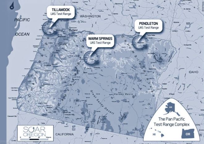
The FCC recently approved three Oregon UAV test ranges; the Tillamook Test Range, the Pendleton Test Range and the Warm Springs Test Range that will get drone products off the ground.
The Warm Springs FAA UAS Test Range, a member of the Pan Pacific UAS Test Range Complex (PPUTRC), is expanding its operations to Prineville and Madras Airports to support Oregon’s rapid UAS industry growth.

The FAA approved the Pan Pacific UAS Test Range Complex, a coalition of three states with test ranges in Alaska, Hawaii and Oregon. Alaska, the coordinator for the 3-state coalition, has begun drone flights with the Aeryon Scout, according to a press release from Peak 3, the Alaska company that contracts with the city of Pendleton to develop and manage its test range at the Eastern Oregon Regional Airport.

Airbus is testing a pilotless flying air taxi in Pendleton. The Airbus Vahana project is working toward the development of a demonstrator aircraft known as the “E-Fan X,” powered by a two-megawatt motor to power a future hybrid commercial single aisle aircraft.

City Airbus expects that on-demand helicopter rides will operate over medium distances, with autonomous vehicles providing the last mile connection. Their Voom smartphone App – or perhaps Moovel’s smartphone app – made right here in Portland – coordinate multiple transportation options in a simple, integrated solution.
Insitu, headquartered in Bingen, Washington, just across the Columbia River from Hood River, was founded by aeronautic engineers Tad McGeer and Andy von Flotow to track schools of tuna for fishing companies.
Insitu currently uses airspace near Arlington and Boardman to test its unmanned aircraft. Oregon’s UAV test ranges in Tillamook, Pendleton and Warm Springs enable local testing.

Congress has instructed the FAA to integrate commercial drones into public airspace, where they will fly in coordination with conventional aircraft.

The FAA selected the University of Alaska’s proposal which contained Hawaii and Oregon UAV test range locations.

In total, 58 companies and 13 test ranges are part of the Pan-Pacific UAS Test Range. Yamhill County hopes to expand drone testing into the northern Willamette Valley and make it a major hub in the emerging field of precision agriculture.
Drone Applications
Electrically powered UAVs are a different class of drones than earlier gas-powered military drones. They are smaller, cheaper and more maneuverable, utilizing cell phone technology. But they have less range, speed and payload. Most electric-powered drones currently have a range of less than a mile and are limited by a 15-30 minute battery. In the United States FAA guidelines limit operations to less than 400 feet for personal use.

But small drones have big potential. Take precision agriculture for example.
- Aerial Technology International in Clackamas sells drones to farmers and film crews
- HoneyComb Corp in Wilsonville manufactures hand-launched drones made from Kevlar with sophisticated guidance and image processing software. It spots areas of distressed crops and counts trees.
- Northwest UAV, a McMinnville company, designs and builds custom propulsion systems
- Pacific NW Labs has outfitted the Articshark drone for Atmospheric Radiation Measurements with testing out of Pendleton.
Stephen Burtt co-founded Aerial Technologies International in Clackamas. Their drone system can fly for up to 25 minutes and is used to help farmers monitor crops or help first responders to monitor oil spills and fires.

Brian Whiteside in Corvallis started Virtual Data Operations Support (VDOS) for software control.

Cessna, Lancair, Epic Aircraft and Windward Performance were hit hard by the economic downturn. But central Oregon now has everything to become a manufacturing hub for pilotless aircraft, say Roger Lee, executive director of the Economic Development Agency of Central Oregon.
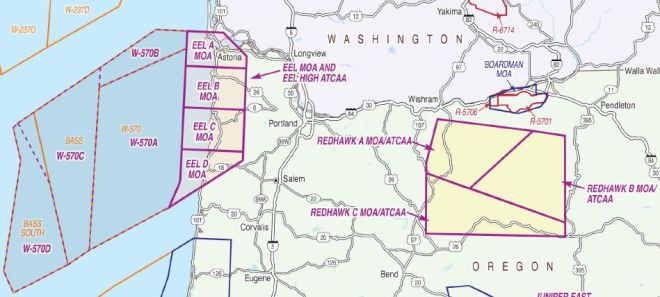
The proposed Oregon Airspace Initiative would expand airspace for the Oregon Air National Guard and establish a new Military Operations Area (MOA) underneath the existing Air Traffic Control Assigned Area along the Oregon coast from Astoria to Lincoln City and adjacent to their other operations area further off the coast.
Logos Technologies utilizes Gorgon Stare for Persistent Surveillance on group 3 UAS platforms like the NAVMAR RQ-23 Tigershark, being tested in Pendleton. The Logos surveillence package has now been shrunk to fit in a small Insitu Integrator payload bay and is being tested in Pendleton.
The Pendleton test range is testing the DOE’s Artic Shark but probably doesn’t even want to talk about the 10,000 ft orbit of a Redkite ultra-lightweight sensor.
Imagine the jurisdictional disputes between FEMA, FAA, DOD, Coast Guard, and other federal and state agencies to get drones positioned after The Big One. A persistent stare would come in handy.
Oregon’s Drone Foundation
The Johnson Near Space Center, at the Port of Tillamook, is the first commercial high altitude balloon and UAS facility in the nation. The new Tillamook Airport facility features both Jet A and Avgas refueling with the main runway one of the longest on the Coast at 5,000 feet.
Insitu’s ScanEagle, a 40-pound aircraft with a 10-foot wingspan, is used for surveillance, search and rescue, and mapping. The remote-controlled devices are equipped with cameras that can transmit real-time video. Insitu’s new RQ-21A Blackjack has an endurance of 16 hours, a payload of 39 lb and 350 watts, and a ceiling of 19,500. It can carry communications relay gear.
The AUVSI Cascade Chapter represents the states of Oregon and Washington. The Small Unmanned Systems Business Exposition was a gathering of the clan. Oregon has been recognized for more than a decade as a hotbed of UAS development, says Belinda Batten, Oregon State engineering professor. Soar Oregon News has more.
Fixed wing drones can fly four to ten hours or more at decent speeds, but often require a runway or catapult for launch and a net to catch them returning. The M80 Stiletto UAV support ship has a Pentamaran hull, carbon fiber construction, and networked architecture.
Aerovel, from the founders of Insitu, is now creating Flexrotor, a next-generation vertical takeoff drone. Aerovel’s 40lb VTOL has Hawaii-to-West Coast range and can be launched and retrieved from an unmanned boat.
VStar Systems, a drone systems integrator, provides radio frequency monitoring via drone.
The best-known drone is probably the Predator drone, manufactured by General Atomics for the U.S. military.

Commercial drones are expected be used for river and transmission line surveillance, spotting forest fires, search and rescues, law enforcement and other applications. DJI’s Matrice 200 UAV line is built for work like bridge and cell tower inspections or emergency response.
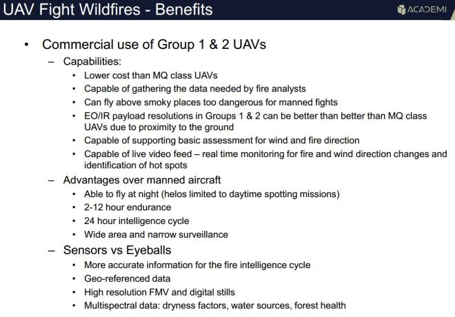
Drones could provide real-time information to firefighters and alert officials when conditions change. “I think you are going to see them sooner than you think,” said Rusty Warbis, flight operations manager at the BLM’s National Aviation Office.
A gas-powered drone helicopter will scout for Oregon forest fires. The G30 Century costs about $1,800, but will run close to $5,000 once it is outfitted it with video and infrared cameras, said Tyson Shultz, a forester assembling the craft and getting qualified to fly it.
Production of a Daily Crop Report is a big driver for small UAV systems. Resson Aerospace is transforming drone footage into customized images and analytics for large agriculture companies.
Cloud-based map and model generation is the future. Apps like Drone Deploy and Propeller Aero make it easy to map routes and upload footage.
The Open Ag Data Alliance (OADA) is creating a data ecosystem that enables interoperability for the entire agriculture industry.
Fast Ascent
Sales of drones — both military and commercial — are expected to reach $89 billion globally over the next decade, according to aerospace-research company Teal Group.
Tom’s Tech Times has an indepth review of the top two 2016 drones, the DJI Phantom 4 ($1200) vrs the Yuneec Typhoon H ($1900).
The Phantom 4 generally comes out far ahead with more software support and lower cost while the Yuneec is bigger and has less range.

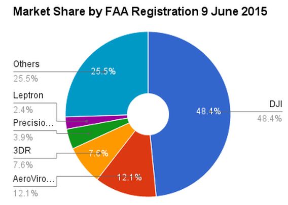
DJI, AeroVironment and 3D Robotics have been the big three in small drones, but new Chinese companies are providing serious competition, especially in the consumer segment.
Domestic commercial drones could be a $13 billion industry by 2017, creating 70,240 jobs, according to the AUVSI. They estimate Oregon’s share at $81 million with about 400 high-skilled, high-paying jobs.
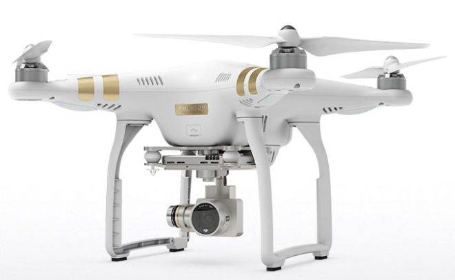
DJI’s Phantom 3 Vision+ shoots 4K video. Parrot’s Bebop drone has Extended Range to a mile or more and can connect to headsets like Oculus Rift and Google glass.
DJI raised $75 million from Accel Partners. Parrot has sold over a million AR.Drone quadcopters since the sUAV was introduced in January of 2010. CyPhy’s received $13.5 million from Motorola Solutions and others and has a successful kickstarter.
Chris Anderson started DIY Drones and later 3D Robotics, a VC-backed startup with over 180 employees in North America and more than 28,000 customers worldwide, doubling its sales every year. ArduPilot (also ArduPilotMega – APM), was created in 2007 by the DIY Drones community, based on the Arduino open-source electronics prototyping platform. 3D Robotics utilizes open source hardware and software. The Android ecosystem is their model.
Forbes profiles the 3D Robotics crash, North America’s Most Promising Drone Company.
Drone Imaging
Third party software support is a biggie. The best selling DJI Phantom 3 Vision+ and Phantom 4 shoot rock-solid 4K video and are supported by the most 3rd party software companies, including cloud-based software as a service.

DJI’s Matrice 200 UAV line is built for work like bridge and cell tower inspections or emergency response.
The $500 Yuneec Breeze drone may be a “toy” but it allows users to edit, caption and save photos and 4K videos and share them on Facebook, Instagram, YouTube and Twitter. The Yuneec Typhoon H uses Intel’s RealSense technology.
Photogrammetry drone software includes PrecisionHawk and Pix4D, which is both a supplier to and a competitor with geospacial giant Esri. Drone2Map for ArcGIS takes raw image data from drones and creates digital surface models, orthomosaics, 3D-point clouds and 3D PDFs that can be shared.
Lidar is now available for small quadcopter drones, creating 3D mapping with point clouds.
This video shows a virtual fly-through using a three-dimensional lidar model of the lower Elwha River just west of Port Angeles.
F2V’s digital maps provide street view-style panoramic imagery, collected from the surface and below the water line are fused with other location-specific data like water quality. F2V’s Elwha River tour used panoramic cameras on an inflatable boat, on a drone, and underwater (for “Fishviews”) of aquatic environments.
A coalition of 15 leading news media companies, including the Oregonian, are testing small drones for news gathering (video).
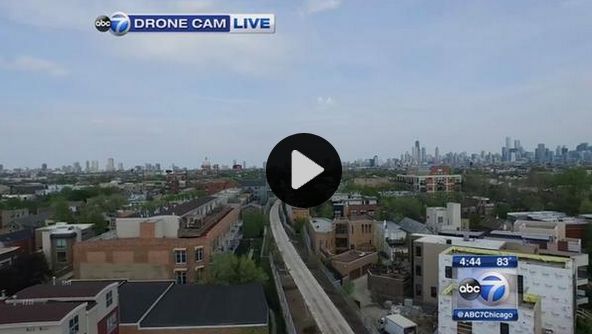
A Chicago TV station was the first to broadcast live HD from a drone (above), flying over a new park trail that is about to open in Chicago. Alpha Media’s news-talk KXL radio in Portland, and the Vancouver Columbian are set to go.
Mount a $350 Theta 360 camera on a drone. Embed it. Done.
SOAR: Oregon’s Drone Kickstarter
Oregon Unmanned Systems Business Enterprise, a nonprofit now called SOAR Oregon, is designed to establish Oregon as a leader in the civilian uses of unmanned aircraft. The organization is launching with a two-year $882,000 state grant from the Oregon Business Development Department and the Oregon Innovation Council.
- Paradigm ISR of Bend for development of a system to collect and analyze pest management data for agricultural crops, $60,000.
- NW UAV of McMinnville, in partnership with the VT Group of Tigard, for completion of a new, certifiable propulsion system for flight vehicles, $75,000.
- Fordyce Design and Manufacturing of Gaston for a standardized servo system for flight vehicles, $14,000.
- Insitu’s Advanced Programs Engineering Group of Hood River for development of flight navigation and communication systems to integrate manned and unmanned aircraft for missions such as firefighting and search and rescue.
- Cloud Cap Technologies to integrate Sagetech’s next generation transponder for development of a new-generation transponder and autopilot for improved flight safety at test ranges and eventually in the general airspace, $103,000.
SoarOregon considered about 40 proposals from area companies in the first round of funding this April. “Oregon has a once-in-a-lifetime opportunity to be on the leading edge of a new industry,” said Mark Morrisson, executive director of SoarOregon. Rick Spinrad, VP for research at Oregon State, is the board president of the new industry group.
Oregon Drone Innovators
PDX drones, founded by Scott Edwards to demonstrate and promote the use of drones, hopes to turn Portland into a hub of activity for Drone development and monetization.
Members build and fly a variety of aircraft, mostly using electric powered propulsion. They use a variety of flight controllers.
A dozen spinoff companies and suppliers from Insitu collectively employ about 1,200 people in the state. There are another 80 drone and aviation-related companies in the region, according to Economic Development for Central Oregon (EDCO).
The Dronecode Project, administered by the nonprofit Linux Foundation, aims to establish common technology for use across the industry. Dronecode includes the APM/ArduPilot UAV software platform and associated code. It has backers like Intel, Qualcomm and Skyward.io.
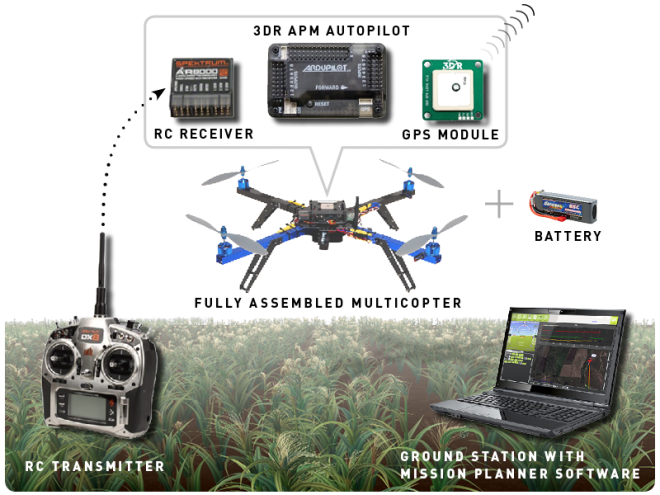
PX4 is an independent, open-source, open-hardware project aiming at providing a high-end autopilot. The PX4 from 3D Robotics features advanced processor and sensor technology for controlling any autonomous vehicle. The 3d Robotics Solo ($1200), their latest packaged drone, can stream live video to the internet, although video range is only .5 miles (using 2.4GHz). At least 10 times that range might be required for first responder applications. Sprint’s new 2.6 GHz 4G system, using their array of 8 antennas, might deliver the punch for long range video.
Skyward IO, promoting controlled airspaces, says Oregon’s test ranges will spawn jobs at tech centers and manufacturing operations. Skyward raised $4.1M in expansion capital to expand the engineering and product development team. Verizon invested in Skyward and is working with regulatory agencies in various countries to plan flight routes and use cases for the Urban Skyways project. The goal is persistent, commercial, digitally- managed airspace.
The Unmanned Aerial System Traffic Management (UTM), developed by NASA, would enable civilian Low-Altitude Airspace and Unmanned Aerial System operations.
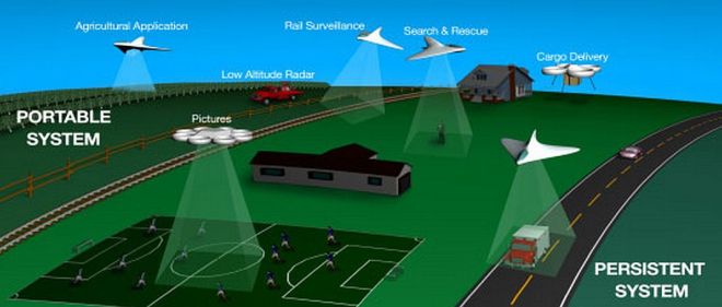
Two types of UTM systems are envisioned (pdf). The first is a Portable UTM System, which would move from between geographical areas and support operations such as precision agriculture and disaster relief. The second type of system is a Persistent UTM System, which would support low-altitude operations and provide continuous coverage for large geographical areas. A UTM prototype is expected by 2019.
Aerial Inspection Resources and VDOS are Oregon-based, FAA authorized UAS inspection companies.
An Elemental Live 4K encoder produced a live 360 degree HD stream of the Red Hot Chili Peppers for delivery to YouTube. Viewers were able to experience the 360˚ stream on Samsung Gear VR and Google Cardboard.
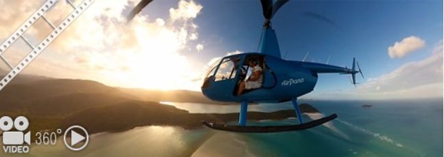
Spherical videos shot with a helicopter by AirPano (above) could be done far cheaper (and better) with a matrix of GoPro cameras on a drone (below).
Google Cardboard is essentially, a $25 VR cardboard housing for a smartphone. With it, viewers can literally fly through a landscape or a city street shot in 360 degrees. Handy for post-apocalyptic 360 degree tours posted on YouTube.
Correlator3D, a software package by SimActive, can be used on drones to input an unlimited number of images at once and seamlessly scale to large projects. Correlator3D UAV software can use your PC with an nVidia card.

Could the military or federal government create a 3D model of the Columbia River channel after a 9.0 earthquake (and aftershocks) cause massive devastation and landslides? Any delay will cost money and lives for Washington and Oregon. We can’t afford NOT to have operational drone photogrammerty.
Beyond Visual Line Of Sight
The next phase of FAA rules may allow operator to fly a craft Beyond Visual Line of Sight (BVLOS). That would likely require a sophisticated (and expensive) radio network along the Columbia River. Both AT&T and Verizon are currently working with local companies to connect cellular LTE networks to drones and make them compliant with any BVLOS rules that emerge from the FAA. Besides cellular networks, however, other licensed and unlicensed options may allow Non Line of Sight.
Columbia River: Drone Superhighway?
The Columbia River is the largest river in the Pacific Northwest and the fourth-largest river in the United States. The average width of the Columbia River is one mile while the length of the Columbia is 1243 miles, beginning in Canada.

The BPA might save tens of thousands of dollars annually if they could survey their high voltage backbone with drones rather than light aircraft. A 350 mile drone corridor from McNary Dam to the Pacific Ocean could monitor vessel and rail traffic.

UgCS software for drones provides 3D visualization of routes with custom 3D objects such as power lines and transmission towers.
Columbia River DART (Data Access in Real Time) provides daily information on fish migration, something the Dept of Fish and Wildlife needs to do with less risk and expense.
Wireless Broadband on the Columbia
Wireless nodes (with integrated drone landing/recharging) might be located near ports every 10-20 miles along the river. Flying at 100-400 feet, Columbia River drones would be provided with constant broadband connectivity for telemetry and live video.

Continuous on-board beaconing would indicate the drone’s presence to other aircraft. A combination of 600MHz and 2.6 GHz (licensed), and 3.5 GHz (shared spectrum) could provide continuous broadband connectivity along the river. For drones and people.
Smarts On-Board
Predator drones are like steam-powered Apollo capsules – virtually all the computer power is remote, requiring large bandwidths. The Movidius Myriad 2 vision processor works in cell phones. It “understands” what it is looking at and enables a drone to intelligently contextualize its surroundings. With computational vision chips, data can be parsed on-board, stripping out relevant metadata from a video image.
Meanwhile, data centers are adding muscle. Computational photography enables all sorts of clever tricks using the cloud to extract invisible data. OpenStack cloud computing controls large pools of compute and storage resources throughout a datacenter, all managed through a dashboard. Open source Puppet is the foundation of the Puppet Labs approach to IT automation. Nvidia combines its Shield tablet with Grid, a cloud-based gaming service that may have implications for many cloud-based applications.
Drone Infrastructure: Business Potential
H.265 encoding, available on Qualcomm’s 810 smartphone processor can reduce HD bandwidth by 50%. Competition from Open source VP10, promoted by Google, avoids the licensing for HEVC. Cisco and Mozilla are contributing their compression technology to an effort to create a royalty-free streaming video standard called NetVC. Meanwhile, Portland’s Elemental Technologies can do the number crunching in the cloud, bring real-time video to all manner of displays.
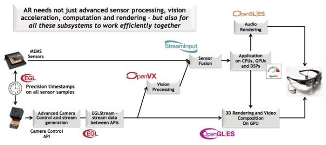
OpenVX provides mobile developers with an industry standard API to deliver embedded computer vision and computational imaging chipsets that can keep UAVs on track.
Cloud Cap autopilots allow precision navigation for complex missions with thousands of waypoints and offers Long-Wave Infrared (LWIR), Mid-Wave Infrared (MWIR), thermal cameras, and Short-Wave Infrared (SWIR) cameras from Sensors Unlimited.
Jonathan Evans, CEO of Portland-based SkyWard.io, explains how the emerging aerial robotics network will operate.
ADS-B is where the airplane simply reports GPS position and altitude. Anybody with any cheap receiver can plot the location electronically. It may replace radar as the primary method for controlling aircraft worldwide.

Aircraft equipped with ADS-B transponders relay precise aircraft location and other flight information to both air-traffic controllers and other ADS-B-equipped planes, much like marine-based AIS systems.
Aireon will use the Iridium NEXT for their ADS-B service, starting in 2015. Globalstar also plans a space-based air traffic management system that will compliment ground-based ADS-B. It’s a true over-the-horizon air traffic surveillance system capable of delivering Air Traffic Control (ATC) automation.
DJI and uAvionix has an ADS-B collision avoidance developer kit that’s among the smallest and lightest ADS-B-based hardware available for unmanned aircraft.
Orbit Logic does Mission Planning for satellites and UAVs.
Portland-based Elemental, Puppet Labs and SkyWard.io do it in the cloud. Today.

Orbit Logic’s SpyMeSat mobile app, available for iPhone and Android, provides notifications when imaging satellites are overhead and will now offer in-app purchase of recent high resolution satellite imagery.
Autonomous Marine Vessels
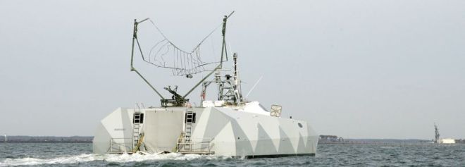
The Navy’s Common Unmanned Surface Vessel (CUSV) is operated by similar command-and-control technology that powers Army UAVs. They can be controlled remotely from 10 to 12 miles away from a command station on land, at sea, or in the air. Bluefin Robotics, a Battelle subsidiary, and the Columbia Group developed the Proteus, an underwater AUV.
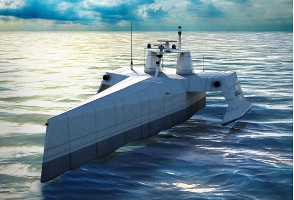
Christenson shipyards in Vancouver is working with Oregon Iron Works on a secret autonomous vessel for SAIC (now Leidos) and DARPA. It can follow enemy submarines for months and travel thousands of miles — without any crew. Carnegie Mellon is developing the vessel’s autonomous software.
DARPA expects to test the operational unmanned vessel prototype in mid-2015. The Anti-Submarine Unmanned Vessel will be was launched April 7 in Portland.

The first ACTUV prototype, named Sea Hunter, was christened on April 7, 2016. Oregon Iron Works, now a wholly owned subsidiary of Vigor Industrial) worked with security contractor Leidos on The Machine.
It was barged back to San Diego for Sea Trials. No LiDar on board. Satcom is said to using the MUOS (“3G) military comms satellite, which means real-time video is probably out. Control is said to be from North Carolina. Perhaps San Diego and Whidbey Island, too, although that’s just speculation.
“We didn’t want a remote-control vessel,” said Scott Littlefield, the project manager for DARPA. “We actually wanted something that could behave appropriately and do complicated missions under what we call ‘sparse human control,'” reports the Oregonian.

DARPA’s Tactically Exploited Reconnaissance Node (TERN) program envisions using smaller ships as mobile launch and recovery sites for medium-altitude, long-endurance UAVs. See: Hayden Island Stealth Boats.
The US Navy recently tested a swarm of robotic gunboats using the Control Architecture for Robotic Agent Command and Sensing (CARACaS) that lets them operate independently while sharing radar data.
Between unmanned airplanes and unmanned boats, the Columbia River should be well patrolled.

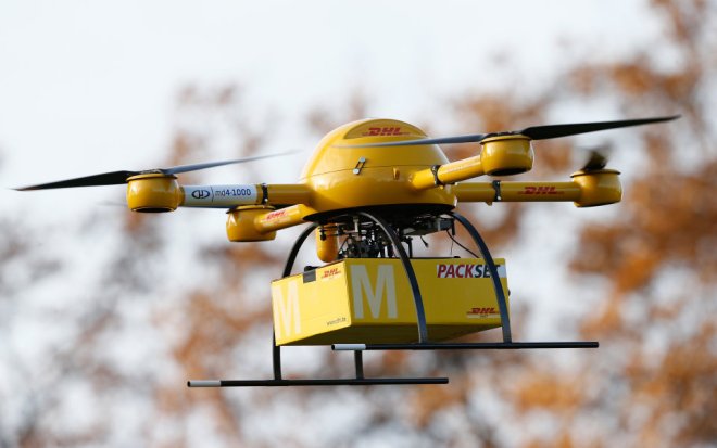
Imagine a future where FedEx in Troutdale or UPS on Swan Island deliver rush items up and down the river.
Drone Video: Going Mainstream
Today Newtek Tricasters and LiveStream Studio can integrate multiple sources into live webcasts. Ultimately, drone video will become ubiquitous — just another another tool.
NFL Now may be instructive in concept and scope. Their live video is fully cross platform, archived, user controlled and in-house. But you don’t have to be the NFL to play. You Tube enables anyone to use drone video — fast, cheap — and live. From any vehicle.
Northwest Benefits
Independent drone operators, not unlike railroads, could offer “common carrier” service on a franchise basis. They may be managed by different governmental jurisdictions. Long-term contracts for railroad, maritime, fishing and forestry industries as well as EPA, ODOT, WDOT and public safety agencies would provide much of the revenue.
Commercial vessels (and communities along the river) could also utilize the broadband wireless network for logistics and commerce. Relatively soon, river-based “skyways” may enable controlled airspace for all manner of individuals and organizations that follow the rules of the road, stimulating new services (such as autonomous vessels) and products.
 Vancouver is River Mile 105 from the mouth of the Columbia. A ScanEagle would only take an hour or so to traverse the entire length.
An autonomous surface vessel would take a little longer.
The development of solar-assisted UAVs, FAA-approved test sites in Oregon, type certification for commercial use over certain restricted areas, ADS-B automation, flight-plan and mission planning software for UAVs, embedded processing chips, FLIR, hyperspectral and Lidar cameras, and broadband wireless connections are moving fast.
Applications in forest and terrain surveys, agricultural monitoring, public safety, maritime and transportation industries are developing just as quickly. Together these innovations may bring a Columbia River Drone Network closer to reality.

Esri’s ArcGIS provides maps and a wide variety of analytical tools to governments, business, and utilities. Esri’s Drone2Map for ArcGIS takes raw image data from drones and creates digital surface models, 3D-point clouds and 3D PDFs that can be shared.

Aviation Week and Flying magazines have been joined by Drone Life, Multirotor Pilot, RotorDroneMag, Robohub.org, Small UAS News, Small UAV Coalition, Flipboard and Reddit with the latest UAV news.
The Oregonian says the smartest thing Oregon can do is to become a capital of drone testing, design and manufacturing.
Maybe it’s time for a drone-based detailed aerial survey of the Gorge, from Umatilla to the Coast, similar to Dogami Lidar Maps but cheaper and with more resolution. Insitu and PrecisionHawk have formed a strategic alliance for unmanned flight for extended and beyond-visual-line-of-sight operations. BNSF Railway will inspect rail infrastructure, beyond visual LOS. The company defined the operating environment as “a 300 or 400-mile capability, to fly looking for broken rail, etc., beyond the visual, on-the-ground inspections that rail crews already do.”
Photogrammetry drone software includes Pix4D and PrecisionHawk. Cloud-based map and model generation is the future and apps like Drone Deploy and Propeller Aero make it easy. The Big One is coming. It pays to be prepared.
The Columbia River has traditionally been used as a natural enabler and catalyst for business. It doesn’t have to be used exclusively as a pipeline for coal and oil.