The U.S. Coast Guard shows the simulated rescue of a kayaker (above) in Dead Man’s Cove on the Columbia River, a popular tourist attraction at Cape Disappointment. The CG station there has 5 search and rescue boats, including: the 52 foot- motor lifeboat “Triumph II”, two 47 foot motor lifeboats, and two 29 foot second generation Defender class response boats. The 52′ and 47′ are designed for operations in heavy surf and are capable of being rolled over by breaking swells and re-right themselves.
The U.S. Army Corps of Engineers and the lower Columbia River ports of Longview, Kalama, Woodland, Vancouver and Portland, along with federal and state agencies, other ports and stakeholders ensure a reliable deep-draft navigation channel.

The Columbia River, from river mile 3 at the Mouth of the Columbia River to river mile 105.5, near Vancouver, Washington, is part of the Columbia & Lower Willamette Federal Navigation Channel Project which maintains a 43 foot depth from Astoria to Vancouver. Approximately 200 timber pile dike structures support the navigation channel through flow redirection, to reduce sediment.
An estimated 10 million cubic yards of sediment is removed from the shipping channel each year. About two-thirds is disposed of in the water, while another third is put on islands and used for beach nourishment. About 15 of the 20 or so designated upland sites where dredge spoils are placed are nearing capacity, according to Jeff Henon, a spokesman for the Army Corps. Nearly 55 million tons of cargo were transported on this stretch in 2015.
Public agencies and private companies have invested more than $1 billion in the lower Columbia River since it was deepened five years ago according to a study by the Pacific Northwest Waterways Association. The U.S. Army Corps of Engineers spent $180 million to deepen the 110-mile navigation channel from 40 to 43 feet. The initial dredging was finished in 2010 and has been instrumental in increasing bulk grain and auto imports, according to the port. Roughly 77 percent of the Port of Portland’s current business is related to movement of agricultural and mineral bulks.

EGT operates the $230 million Export Grain Terminal at Longview, which was the first new grain export facility in North America in roughly 25 years. It’s a joint venture between Bunge North America and ITOCHU International, a Japanese trading company.
The locks for the eight dams between Portland on the Columbia River and Lewiston on the Snake River were taken out of service Dec. 12, 2016 for a 14-week maintenance outage. Maintenance iscludes removing existing navigation locks and installing new redundant control systems.

Forty percent of the nation’s wheat moves on the Snake and Columbia rivers, with goods of all kinds transported annually valued at $3 billion. The most common cargo are agricultural products, petroleum products and steel and other metal items. The US Army Corp districts manage the locks and dams that comprise the 359-mile-long federally authorized inland navigation channel extending upriver from Portland, Oregon, to Lewiston, Idaho.
Upriver Ports — Distance from Portland
- Port of Lewiston (Idaho) 360 miles, 47 hours
- Port of Pasco (Wash.) 225 miles, 31 hours
- Port of Umatilla (Ore.) 187 miles, 25 hours
- Port of Morrow (Boardman, Ore.) 170 miles, 23 hours
Each river pilot carries a laptop loaded with a tracking system to monitor ship traffic on the river. River pilots also meet with the U.S. Army Corps of Engineers at least once a month to review the agency’s monthly river surveys. They look for areas where sand and silt are building up and areas where maintenance dredging will be done.
The Portland Corps of Engineers keeps Oregon’s waterways safe and navigable through dredging sandbars and channel deepening, ensuring safe transport for more than $18 billion in waterborne commerce.

Columbia River surveys are channel-line and cross-line surveys of the Columbia from The Mouth of the Columbia to Vancouver Turning Basin. Channel-line surveys are survey lines which run parallel to the channel, 7 lines across, 150 feet apart.
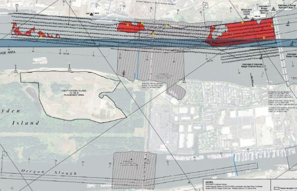
Cross-line surveys are lines that run perpendicular to the channel, bank-to-bank and are generally 500 feet apart.

The Portand Tribune has the story of the forgotten River Queen which was a floating restaurant near the Broadway Bridge in the 1970s.

The ‘River Queen’ restaurant ended up as a derelict vessel on the Columbia near Goble and work was started to remove it in June, 2017.

Abandoned and derelict vessels are vessels that are left without authorization on public or private land, or State waters; and/or are sinking, actively polluting. Most of the work to remove and dispose of derelict and abandoned vessels on state-owned aquatic lands is done by private contractors.

Boating and Sailing Info
- Oregon State Marine Board
- National Data Buoy Center (NOAA)
- SailPdx
- Charts: Columbia River – Vancouver to Bonneville
- Charts: Port of Portland, including Vancouver & Multnomah
- Coastal Waters Forecast
- Northwest River Forecast
- Columbia River Boating Links
Boating and Sailing Clubs:
- Columbia River Yachting Association
- Columbia Gorge Racing Association
- Columbia River Kayaking
- Columbia Drag Boat Association
- Corinthian Yacht Club
- Oregon Women’s Sailing Association
- Portland Yacht Club
- Small Yacht Sailing Club of Oregon
- Vancouver Lake Sailing Club
- Willamette Sailing Club
- Whitewater Rafting & Kayaking
Marine Patrols:
- US Coast Guard: Sector Columbia River
- Coast Guard Nav Center, Region 13
- Multnomah County Marine Patrol
- Clark County Marine Patrol
- Coast Guard Auxiliary
- Sea Scouts
Unions and Management
- Pacific Maritime Association
- International Container Services Oregon
- International Longshoreman Union


