Sloughs: Draining the Swamp
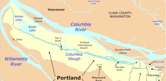
The Columbia Slough is a narrow waterway, about 19 miles long, in the floodplain of the Columbia River. The Columbia Slough is a remnant of the historic wetlands between the mouths of the Sandy River to the east and the Willamette River to the west.
The Multnomah County Drainage District helps protect lives and property from flooding by operating and maintaining stormwater and flood management systems for over 1200 acres of land along the Columbia Slough and the lower Columbia River.

The 19-mile-long Columbia Slough, the remnant of an old wetland, is controlled by floodgates and pumps. It reduces the possibility of catastrophic flooding and lowers insurance costs for landowners. Recertification of levees is required every 10 years by the Federal Emergency Management Agency so property owners can qualify for flood insurance.
The nearby Multnomah Channel (Willamette Slough), below, travels along the south side of Sauvie Island, beginning near the west side of the Willamette, near Kelly Point Park, at the confluence of the Willamette and Columbia Rivers. It re-enters the Columbia near St. Helens.

There are 12 pump stations operated and maintained by the Drainage Districts.
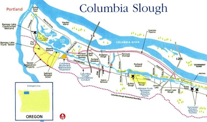
The Columbia Slough Watershed Council is a diverse group of neighbors, property owners, businesses and government agencies who work to restore and enhance the 60 miles of waterways known as the Columbia Slough. Their annual Columbia Slough Regatta at the St Johns Launch (9387 N Columbia Blvd) in August provides canoes and kayaks to launch into the safe slack water of the Columbia Slough.

The mission of the Columbia Slough Watershed Council is to protect and enhance the Columbia Slough which runs about a mile south of the Columbia, from near Blue Lake Park in the east to Kelley Point Park in the west. The slough became one of Oregon’s most polluted waterways until the recent cleanup. Today it is one of the nation’s largest freshwater urban wetlands, with Smith and Bybee Wetlands Natural Areas sharing the lower slough watershed with a sewage treatment plant, marine terminals, a golf course, and a car racetrack.


As part of the Columbia Slough Watershed, a new Sewer Pump Station is being installed in the Safeway parking lot. The new Safeway Pump Station on Hayden Island will house two larger pumps, to reduce the possibility of sewage releases into rivers, homes and businesses.

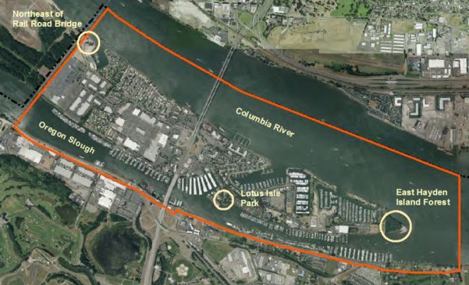
Kenton’s northern border is formed by North Portland Harbor, the channel of the Columbia River that separates Hayden Island from Oregon’s mainland. The Bridgeton Neighborhood is on North Portland Harbor which some people confuse with the slough.

North Portland Harbor was previously called the Oregon Slough, but it is really just the south section of the Columbia River.
The west end of the Columbia Slough is at Kelly Point Park, near the Port’s Rivergate Industrial District, south of Hayden Island. The Columbia Slough is about one-half mile south of the Columbia River and runs parallel to it, running past Smith and Bybee lakes and Portland International Airport. A bike path travels along much of the Slough.
Sewage flows downhill through pipes called gravity sewers in most of Portland’s collection system. The Columbia Boulevard Treatment Plant serves nearly 600,000 residential and commercial customers. Pump stations are located at low points in the system to pump wastewater uphill.
The North Portland Peninsula railroad tunnel, near N Columbia Blvd (north portal), shortens freight movement north over the Columbia River to Washington State. The Slough largely parallels The Kenton Line, which feeds UP traffic to the Port of Portland.

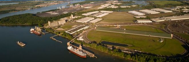
Terminal 5 features a grain elevator operated by Columbia Grain and a potash export facility in a 2,000-foot-long storage building run by PotashCorp, while Terminal 6, along North Portland Harbor, specializes in containers and cars.
Levees surround much of the main slough as well as many side sloughs and nearby lakes. The region’s 4 Drainage Districts operate 13 Pump Stations, 27 Miles of Levees, and approximately 45 Miles of Ditches, Slough, and Streams. Employees control water flows with pumps and floodgates.

During the early 1920s, levee construction began to prevent the Columbia River’s annual spring floods. As the area developed, what was once a wildlife-rich mosaic of sloughs, wetlands and lakes was transformed into a highly managed system of channels, agricultural lands, industrial development, and residences.

One of the nation’s largest freshwater urban wetlands, Smith and Bybee Wetlands Natural Area shares the lower slough watershed with The Portland Expo Center, Portland’s marine terminals, the Columbia Boulevard Treatment Plant, a Heron Lakes Golf course, Portland International Raceway, Delta Park and Historic Vanport.

The areas levees must now be accredited within FEMA’s National Flood Insurance Program by drilling boreholes and removing soil samples at periodic intervals along the levee system.

The Columbia Slough collects stormwater runoff, rainwater, and groundwater. Its streams, sloughs, wetlands, grasslands and woodlands provide wildlife corridors and migratory routes for over 175 species of birds. Mink, river otter, beaver, coyote and sensitive species like Bald Eagle, Peregrine Falcon, Willow Flycatcher, and Western Pond and Painted turtles use slough habitats. Twenty eight fish species call the Columbia Slough home.

The Columbia Slough Regatta is held annually in August. The public is invited to paddle along the slough with boats available at no charge. Biking along the Slough and Smith and Bybee Lakes is pleasant and part of the 40 mile loop around the city.
McCuddy’s Marinas extend from Government Island to Ridgefield.

Links:
- Columbia Slough Watershed Council
- The Columbia Slough (Wikipedia)
- Levee Ready Columbia
- Columbia South Shore Well Field
- Portland North Harbor Neighbors
- The Bridgeton neighborhood
- Kenton neighborhood
- Historic Vanport
- Delta Park
- Kelly Point Park
- Smith and Bybee Wetlands
- Drainage Districts
- The Columbia Slough Regatta
- Canoeing & Kayaking
- Slough Biking and Recreation
- Images of North Portland Harbor


